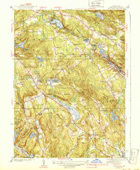
1939 Map of Montville
USGS Topo · Published 1939About this map
Montville and the surrounding hill country of New London County appear here as a landscape defined by an intricate network of water resources and small, dispersed settlements. Before the post-war expansion of coastal Connecticut, this 1930s survey reveals a region of small schoolhouses like the Manywaring Sch and the Schofield Sch, alongside industry-related ponds such as Oakdale Pond and Rockland Pond. The Central Vermont railroad tracks follow the corridor of Falls Brook through the heart of the village, serving as a primary link between the inland hills and the coast.
Find a feature on this map
85 named features on this map. Tap any name to fly to it.
Don’t see what you’re looking for? This feature index may not catch every label — zoom into the map to look around manually.
Map Details
Editions of this 1939 Montville Map
3 editions found

Other maps of this area

1892 · New London
USGS Topo · 1:62,500

1892 · Norwich
USGS Topo · 1:62,500

1892 · Gilead
USGS Topo · 1:62,500

1893 · New London
USGS Topo · 1:62,500

1893 · Saybrook
USGS Topo · 1:62,500

1921 · New London
USGS Topo · 1:62,500

1934 · Niantic
USGS Topo · 1:24,000

1935 · Montville
USGS Topo · 1:24,000

1938 · New London
USGS Topo · 1:31,680

1938 · Niantic
USGS Topo · 1:62,500