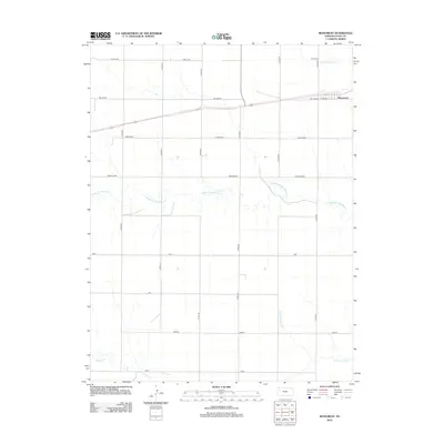
2012 Map of Monument
USGS Topo · Published 2012About this map
Monument sits at the crossing of highway and rail lines in this Logan County landscape, serving as the primary hub for the surrounding agricultural plains. The town's layout is anchored by a local School, while the rest of the quadrangle is defined by a rigid grid of rural routes. These roads bear evocative names like Eagle Eye, Day Dream, and Broken Bow, reflecting a structured approach to land management in western Kansas. The terrain is subtly drained by several branches of Hackberry Creek, including the Middle Br Hackberry Cr, N Br Hackberry Cr, and S Br Hackberry Cr. In the southwest, Sixmile Cr meanders near the rural crossing of Vista. This 2012 survey illustrates the enduring relationship between the high plains road network and the sparse watercourses that shape the region's geography.
Find a feature on this map
20 named features on this map. Tap any name to fly to it.
Don’t see what you’re looking for? This feature index may not catch every label — zoom into the map to look around manually.
Map Details
Editions of this 2012 Monument Map
This is the sole edition of this map. No revisions or reprints were ever made.
Other maps of this area

1954 · Goodland
USGS Topo · 1:250,000

1955 · Scott City
USGS Topo · 1:250,000

1956 · Goodland
USGS Topo · 1:250,000

1957 · Goodland
USGS Topo · 1:250,000

1958 · Scott City
USGS Topo · 1:250,000

1972 · Russell Springs
USGS Topo · 1:24,000

1972 · Monument
USGS Topo · 1:24,000
1972 · Winona
USGS Topo · 1:24,000

1972 · Winona NE
USGS Topo · 1:24,000
1972 · Winona NW
USGS Topo · 1:24,000