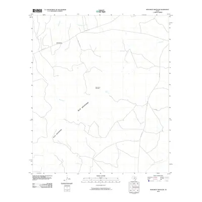
2010 Map of Monument Mountain
USGS Topo · Published 2010About this map
Blue Mountain Community Hall stands as a primary focal point in this portion of the Texas Hill Country, situated near the headwaters of several drainage systems. The landscape is defined by the prominent Blue Mountains and the distinct peak of Monument Mountain, which dictate the winding paths of the local road network. The hydrologic pattern reveals a complex web of seasonal and perennial waterways, including the southward flow of Rocky Creek and Little Rocky Creek, while the James River crosses the southern reaches of the quadrangle.
Find a feature on this map
12 named features on this map. Tap any name to fly to it.
Don’t see what you’re looking for? This feature index may not catch every label — zoom into the map to look around manually.
Map Details
Editions of this 2010 Monument Mountain Map
This is the sole edition of this map. No revisions or reprints were ever made.
Other maps of this area

1887 · Mason
USGS Topo · 1:125,000

1894 · Mason
USGS Topo · 1:125,000

1894 · Kerrville
USGS Topo · 1:125,000

1954 · Llano
USGS Topo · 1:250,000

1955 · Llano
USGS Topo · 1:250,000

1956 · Llano
USGS Topo · 1:250,000
1967 · Monument Mountain SE
USGS Topo · 1:24,000

1968 · Monument Mountain
USGS Topo · 1:24,000
1968 · Turtle Creek
USGS Topo · 1:24,000

1968 · Sheep Run Creek
USGS Topo · 1:24,000