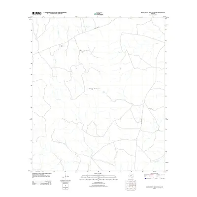
2012 Map of Monument Mountain
USGS Topo · Published 2012About this map
Blue Mountain Community Hall stands as a focal point for this rural stretch of Kimble County, situated near the northern edge of the Blue Mountains. This landscape is defined by the headwaters and drainage systems of several significant local waterways, including Rocky Cr, Little Rocky Cr, and Mill Cr, which eventually lead toward the James River in the south. The terrain is marked by significant rises such as Monument Mtn, where the elevation changes are punctuated by natural water sources like Walnut Spring.
Find a feature on this map
12 named features on this map. Tap any name to fly to it.
Don’t see what you’re looking for? This feature index may not catch every label — zoom into the map to look around manually.
Map Details
Editions of this 2012 Monument Mountain Map
This is the sole edition of this map. No revisions or reprints were ever made.
Other maps of this area

1887 · Mason
USGS Topo · 1:125,000

1894 · Mason
USGS Topo · 1:125,000

1894 · Kerrville
USGS Topo · 1:125,000

1954 · Llano
USGS Topo · 1:250,000

1955 · Llano
USGS Topo · 1:250,000

1956 · Llano
USGS Topo · 1:250,000
1967 · Monument Mountain SE
USGS Topo · 1:24,000

1968 · Monument Mountain
USGS Topo · 1:24,000
1968 · Turtle Creek
USGS Topo · 1:24,000

1968 · Sheep Run Creek
USGS Topo · 1:24,000