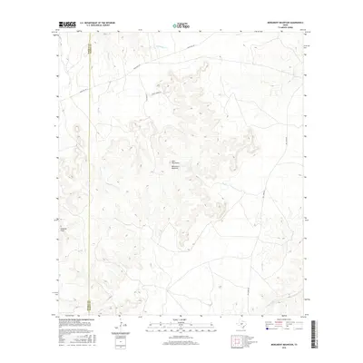
2016 Map of Monument Mountain
USGS Topo · Published 2016About this map
Monument Mountain and the Blue Mountains define the central topography of this Texas Hill Country terrain near the border of Kimble and Mason counties. The landscape is characterized by a complex network of seasonal drainage and perennial water sources, including the headwaters of Mill Cr, Rocky Cr, and the flow of the James River in the southeast corner. Significant natural landmarks such as Walnut Spring and Edwards Draw indicate the historical importance of water access in this ranching region. Transportation is facilitated by a few key corridors like Ranch Rd 1871, while private tracks such as Ernest Jordan Rd and Blue Mtn Ln provide access to the interior uplands. This 2016 survey illustrates a largely rural and undeveloped portion of the Edwards Plateau, where the land use is dictated by the limestone-carved contours and river valleys.
Find a feature on this map
13 named features on this map. Tap any name to fly to it.
Don’t see what you’re looking for? This feature index may not catch every label — zoom into the map to look around manually.
Map Details
Editions of this 2016 Monument Mountain Map
This is the sole edition of this map. No revisions or reprints were ever made.
Other maps of this area

1887 · Mason
USGS Topo · 1:125,000

1894 · Mason
USGS Topo · 1:125,000

1894 · Kerrville
USGS Topo · 1:125,000

1954 · Llano
USGS Topo · 1:250,000

1955 · Llano
USGS Topo · 1:250,000

1956 · Llano
USGS Topo · 1:250,000
1967 · Monument Mountain SE
USGS Topo · 1:24,000

1968 · Monument Mountain
USGS Topo · 1:24,000
1968 · Turtle Creek
USGS Topo · 1:24,000

1968 · Sheep Run Creek
USGS Topo · 1:24,000