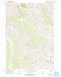
1967 Map of Monument Peak
USGS Topo · Published 1972About this map
The Washakie Needles tower over the northern portion of this 1967 survey, marking a distinct alpine landscape within the Shoshone National Forest. This high-elevation terrain is defined by the Wind River Indian Reservation Boundary, which cuts across the central part of the quadrangle, separating reservation lands from the surrounding forest and county jurisdictions. The drainage patterns of the Absaroka Range are clearly visible, with numerous watercourses like Owl Creek and Bear Creek carving through the steep topography.
Find a feature on this map
30 named features on this map. Tap any name to fly to it.
Don’t see what you’re looking for? This feature index may not catch every label — zoom into the map to look around manually.
Map Details
Editions of this 1967 Monument Peak Map
2 editions found
Other maps of this area

1904 · Kirwin
USGS Topo · 1:125,000

1906 · Kirwin
USGS Topo · 1:125,000

1955 · Thermopolis
USGS Topo · 1:250,000

1958 · Thermopolis
USGS Topo · 1:250,000

1962 · Thermopolis
USGS Topo · 1:250,000

1967 · Willow Creek
USGS Topo · 1:24,000
1967 · Circle Ridge
USGS Topo · 1:24,000

1967 · Monument Peak
USGS Topo · 1:24,000
1967 · East Fork Basin
USGS Topo · 1:24,000
1967 · Johnson Draw
USGS Topo · 1:24,000