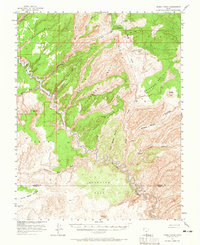
1953 Map of Moody Creek
USGS Topo · Published 1965About this map
The Escalante River carves a deep, winding course through this mid-century landscape of high benches and sheer canyon walls. Published in cooperation with the Atomic Energy Commission, the map reflects a period of active mineral exploration across the Colorado Plateau. This activity is evidenced by the presence of the Hotshot Prospect, Sneaky Prospect, and a remote Landing Strip near the headwaters of Moody Creek. The terrain is defined by massive formations such as the Circle Cliffs and the wide expanse of Baker Bench. South of the Garfield Co and Kane Co line, the geography shifts toward Scorpion Flat and the intricate drainages of Scorpion Gulch. Named features like Egypt and the Purple Hills highlight the distinctive character of this isolated backcountry before more modern infrastructure arrived.
Find a feature on this map
34 named features on this map. Tap any name to fly to it.
Don’t see what you’re looking for? This feature index may not catch every label — zoom into the map to look around manually.
Map Details
Editions of this 1953 Moody Creek Map
4 editions found

Other maps of this area

1886 · Escalante
USGS Topo · 1:250,000

1886 · Henry Mountains
USGS Topo · 1:250,000

1892 · Henry Mountains
USGS Topo · 1:250,000

1922 · Rees Canyon
USGS Topo · 1:63,360

1953 · Mt Pennell
USGS Topo · 1:62,500

1953 · Circle Cliffs 1 SE
USGS Topo · 1:24,000

1953 · Circle Cliffs 4 NW
USGS Topo · 1:24,000

1953 · Circle Cliffs 1 SW
USGS Topo · 1:24,000

1953 · Mt Pennell 3 NW
USGS Topo · 1:24,000

1953 · Mt Pennell 3 SW
USGS Topo · 1:24,000