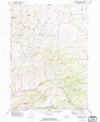
1971 Map of Moonlight Mtn
USGS Topo · Published 1974About this map
The Fort Hall Indian Reservation Boundary cuts a straight line across this 1971 survey of the Pocatello Range, separating the northern tribal lands from the complex topography of southeastern Idaho. The landscape is defined by the high elevations of Moonlight Mountain and Camelback Mountain, which overlook a network of seasonal water sources including Waterhouse Spring, Big Spring, and Snipe Spring. This area reflects a quiet resource-extraction history, visible in the Moonlight Mine and scattered prospect pits found along the Moonlight Creek drainage. To the north, the terrain transitions toward the drainage of the Ross Fork South Fork, where rural infrastructure like Smoke Road and Wheeler Road provided access to the high country. The abundance of named springs across these ridges suggests the critical importance of water management for local ranching and land use in this arid mountain environment during the early 1970s.
Find a feature on this map
34 named features on this map. Tap any name to fly to it.
Don’t see what you’re looking for? This feature index may not catch every label — zoom into the map to look around manually.
Map Details
Editions of this 1971 Moonlight Mtn Map
2 editions found
Other maps of this area

1937 · Pocatello
USGS Topo · 1:48,000

1940 · Blackfoot
USGS Topo · 1:62,500

1943 · Blackfoot
USGS Topo · 1:62,500

1944 · Pocatello
USGS Topo · 1:62,500

1954 · Pocatello
USGS Topo · 1:250,000

1955 · Yandell Springs
USGS Topo · 1:62,500

1955 · Idaho Falls
USGS Topo · 1:250,000

1958 · Idaho Falls
USGS Topo · 1:250,000

1958 · Pocatello
USGS Topo · 1:250,000
1968 · South Putnam Mtn
USGS Topo · 1:24,000