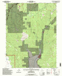
1994 Map of Moonlight Peak
USGS Topo · Published 1998About this map
Moonlight Peak and the surrounding high country of the Lassen National Forest and Plumas National Forest define this 1990s-era map of Northern California's Sierra Nevada. The landscape is heavily marked by the region's industrial past, particularly the copper mining history found at Engel Mine and the extensive Tailings and China Tailings along Lights Creek. Evidence of early settlement and resource extraction is visible in landmarks like Shake Cabin and the presence of a Cem tucked into the lower valley near Indian Valley. These features indicate a terrain where commercial enterprise and wilderness management overlap, with old Ditch lines and scattered Spring sites supporting early homesteading or mining operations. The network of service roads, many marked as Closed, shows the transition from active extraction to forest conservation and watershed protection in the late twentieth century.
Find a feature on this map
28 named features on this map. Tap any name to fly to it.
Don’t see what you’re looking for? This feature index may not catch every label — zoom into the map to look around manually.
Map Details
Editions of this 1994 Moonlight Peak Map
This is the sole edition of this map. No revisions or reprints were ever made.
Other maps of this area

1886 · Honey Lake
USGS Topo · 1:250,000

1891 · Honey Lake
USGS Topo · 1:250,000

1893 · Honey Lake
USGS Topo · 1:250,000

1950 · Kettle Rock
USGS Topo · 1:62,500

1950 · Greenville
USGS Topo · 1:62,500

1954 · Susanville
USGS Topo · 1:62,500

1955 · Westwood
USGS Topo · 1:62,500

1955 · Westwood
USGS Topo · 1:250,000

1958 · Westwood
USGS Topo · 1:250,000

1959 · Westwood
USGS Topo · 1:250,000