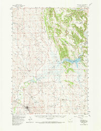
1957 Map of Moorcroft
USGS Topo · Published 1985About this map
Moorcroft serves as a vital junction in the late 1950s, where the Chicago Burlington and Quincy railroad tracks meet the historical path of the Texas Trail. This landscape is defined by the massive footprint of the Keyhole Reservoir, held by the Keyhole Dam along the Belle Fourche River. The map captures an era of ranching and early petroleum development, with numerous Oil Wells scattered across the northern draws near Oil Butte. Local landmarks like the Historical Mon and the Rodeo Ground near town highlight the community's cultural roots. To the east, the Pine Ridge and Dakota Divide provide a sharp contrast to the river bottomlands, while family names are preserved through properties such as the Robinson Ranch and Schuricht Ranch.
Find a feature on this map
64 named features on this map. Tap any name to fly to it.
Don’t see what you’re looking for? This feature index may not catch every label — zoom into the map to look around manually.
Map Details
Editions of this 1957 Moorcroft Map
3 editions found

Other maps of this area

1905 · Devils Tower
USGS Topo · 1:125,000

1918 · Moorcroft
USGS Topo · 1:125,000

1918 · Moorcroft
USGS Topo · 1:62,500

1954 · Sunny Divide
USGS Topo · 1:24,000

1954 · Carlile
USGS Topo · 1:24,000

1954 · Missouri Buttes
USGS Topo · 1:24,000

1954 · Gillette
USGS Topo · 1:250,000

1955 · Devils Tower
USGS Topo · 1:62,500

1955 · Gillette
USGS Topo · 1:250,000

1957 · Nefsy Divide
USGS Topo · 1:62,500