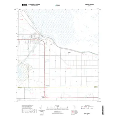
2018 Map of Moore Haven
USGS Topo · Published 2018About this map
Moore Haven serves as the focal point of this modern topographical study, situated at the critical junction where the Okeechobee Waterway and Caloosahatchee Canal meet. The town's grid, including streets like El Dorado Ave NW and Azalea Ave, sits protected behind the massive Herbert Hoover Dike. This engineering feat separates the inhabited lands from the marshes of Lake Hicpochee and the Rim Canal. To the south, the landscape is defined by agricultural drainage systems like Ninemile Canal and smaller rural settlements such as Benbow and Whidden Corner. The presence of the Florida National Scenic Trail following the dike highlights the area's transition from an industrial waterway hub to a site for recreational transit. Tracing the Old Moore Haven Canal alongside newer developments illustrates the long-term water management strategies that have shaped the Glades and Hendry County borderlands.
Find a feature on this map
56 named features on this map. Tap any name to fly to it.
Don’t see what you’re looking for? This feature index may not catch every label — zoom into the map to look around manually.
Map Details
Editions of this 2018 Moore Haven Map
This is the sole edition of this map. No revisions or reprints were ever made.
Other maps of this area

1956 · West Palm Beach
USGS Topo · 1:250,000

1957 · West Palm Beach
USGS Topo · 1:250,000

1958 · West Palm Beach
USGS Topo · 1:250,000

1970 · Moore Haven
USGS Topo · 1:24,000

1970 · Clewiston South
USGS Topo · 1:24,000
1970 · Lakeport
USGS Topo · 1:24,000

1970 · La Belle 4 NW
USGS Topo · 1:24,000

1970 · La Belle 4 NE
USGS Topo · 1:24,000
1971 · Fisheating Bay
USGS Topo · 1:24,000
1971 · Clewiston North
USGS Topo · 1:24,000