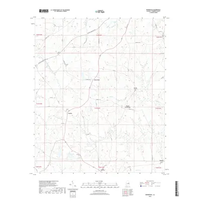
2018 Map of Moorefield
USGS Topo · Published 2018About this map
Oak Bowery and its surrounding rural communities are situated among the headwaters and tributaries of several prominent creeks in this central Alabama landscape. The settlement pattern is defined by traditional crossroads and small clusters like Sturkie and Liberty Crossroads, connected by an extensive network of county roads. For genealogists, the map is particularly valuable for its documentation of numerous burial grounds including Antioch Cem, Boyds Cem, and Spratling Cem, which serve as physical markers of the area's family histories. The drainage of the land is visible through the winding paths of Little Chattahoochee Cr and Boyds Cr, while modern infrastructure is represented by the path of Veterans Memorial Pkwy cutting across the northern sections. Small water bodies like Jeff Beards Lake and J H Hines Lake further detail the local topography.
Find a feature on this map
63 named features on this map. Tap any name to fly to it.
Don’t see what you’re looking for? This feature index may not catch every label — zoom into the map to look around manually.
Map Details
Editions of this 2018 Moorefield Map
This is the sole edition of this map. No revisions or reprints were ever made.
Other maps of this area

1906 · Dadeville
USGS Topo · 1:125,000

1907 · Opelika
USGS Topo · 1:125,000

1909 · Opelika
USGS Topo · 1:125,000

1955 · Phenix City
USGS Topo · 1:250,000

1957 · Phenix City
USGS Topo · 1:250,000

1958 · Phenix City
USGS Topo · 1:250,000

1970 · Opelika East
USGS Topo · 1:24,000

1971 · Waverly
USGS Topo · 1:24,000
1971 · Cusseta
USGS Topo · 1:24,000
1971 · Moorefield
USGS Topo · 1:24,000