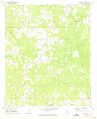
1971 Map of Moorefield
USGS Topo · Published 1973About this map
Moorefield and the surrounding agricultural landscape of Chambers County appear here as they were documented in the early 1970s. This survey emphasizes the rural connectivity of the region, anchored by small community centers like Liberty Crossroads and Sturkie. The land is defined by a dense network of drainage systems, including Little Chatahospee Creek and Little Sandy Creek, which navigate the undulating terrain characteristic of east Alabama.
Find a feature on this map
20 named features on this map. Tap any name to fly to it.
Don’t see what you’re looking for? This feature index may not catch every label — zoom into the map to look around manually.
Map Details
Editions of this 1971 Moorefield Map
This is the sole edition of this map. No revisions or reprints were ever made.
Other maps of this area

1906 · Dadeville
USGS Topo · 1:125,000

1907 · Opelika
USGS Topo · 1:125,000

1909 · Opelika
USGS Topo · 1:125,000

1955 · Phenix City
USGS Topo · 1:250,000

1957 · Phenix City
USGS Topo · 1:250,000

1958 · Phenix City
USGS Topo · 1:250,000

1970 · Opelika East
USGS Topo · 1:24,000

1971 · Waverly
USGS Topo · 1:24,000
1971 · Cusseta
USGS Topo · 1:24,000
1971 · Lafayette
USGS Topo · 1:24,000