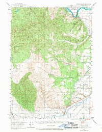
1951 Map of Moores Hollow
USGS Topo · Published 1967About this map
The Oregon Trail cuts through this landscape along the border of Oregon and Idaho, marking a historic corridor of western migration. Near the confluence of the Snake River and Malheur River, the terrain transitions from the irrigated agricultural lands of Weiser Flat and Ontario Heights to the higher elevations of Pine Tree Ridge and Tub Mountain. This 1951 survey illustrates a complex network of water management essential for the region's development, featuring the Pacific Canal, Halliday Canal, and several reservoirs like Love Reservoir. The presence of the Union Pacific railroad and the Ontario Airport highlights the area's mid-century role as a transportation hub, while family-named landmarks such as Jacobsen Gulch and Shepherd Gulch provide specific points of interest for local history researchers and genealogists.
Find a feature on this map
51 named features on this map. Tap any name to fly to it.
Don’t see what you’re looking for? This feature index may not catch every label — zoom into the map to look around manually.
Map Details
Editions of this 1951 Moores Hollow Map
3 editions found
Other maps of this area

1897 · Weiser
USGS Topo · 1:125,000

1898 · Nampa
USGS Topo · 1:125,000

1906 · Mitchell Butte
USGS Topo · 1:125,000

1950 · Jamieson
USGS Topo · 1:62,500

1951 · Moores Hollow
USGS Topo · 1:24,000

1951 · Malheur Butte
USGS Topo · 1:24,000

1951 · Moores Hollow
USGS Topo · 1:62,500

1951 · Payette
USGS Topo · 1:24,000

1951 · Huntington
USGS Topo · 1:62,500

1951 · Weiser South
USGS Topo · 1:24,000