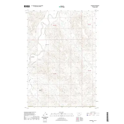
2020 Map of Moorhead
USGS Topo · Published 2020About this map
Moorhead stands near the confluence of the Powder River and Graham Cr in this northern Montana landscape. The settlement is defined by its relationship to the winding river valley and the significant elevation changes found at Kelsey Hill and the uniquely named The Devils Backbone to the south. The terrain is deeply carved by drainage systems including Kelsey Draw, Bootjack Draw, and numerous seasonal waterways like Flood Cr, Cliff Cr, and Thompson Cr. A primary transportation corridor follows the river via Moorhead Rd and Big Powder River East Rd, connecting the scattered ranchlands. This survey illustrates the remote character of Powder River Co near the state line, where the land is divided into townships and ranges that overlay a complex network of creeks such as Bitter Creek and Buffalo Cr.
Find a feature on this map
26 named features on this map. Tap any name to fly to it.
Don’t see what you’re looking for? This feature index may not catch every label — zoom into the map to look around manually.
Map Details
Editions of this 2020 Moorhead Map
This is the sole edition of this map. No revisions or reprints were ever made.
Other maps of this area

1954 · Ekalaka
USGS Topo · 1:250,000

1954 · Gillette
USGS Topo · 1:250,000

1955 · Gillette
USGS Topo · 1:250,000

1956 · Ekalaka
USGS Topo · 1:250,000

1958 · Gillette
USGS Topo · 1:250,000

1958 · Ekalaka
USGS Topo · 1:250,000

1962 · Gillette
USGS Topo · 1:250,000

1965 · Ekalaka
USGS Topo · 1:250,000

1970 · Moorhead
USGS Topo · 1:24,000

1970 · Bloom Creek
USGS Topo · 1:24,000