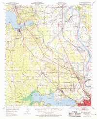
1955 Map of Mooringsport
USGS Topo · Published 1969About this map
Pine Island Gas and Oil Field dominates the northern landscape of Caddo Parish, where a dense network of wells and pipelines traces the mid-century energy boom. Near the town of Mooringsport, a Powerplant sits along the southern shore of Caddo Lake, a centerpiece of the region's industrial and recreational geography. The era's social fabric is visible in the numerous rural institutions, including the Rosenwald Sch, St Paul Sch, and Rose of Sharon Ch, which served established communities like Dixie and Blanchard.
Find a feature on this map
106 named features on this map. Tap any name to fly to it.
Don’t see what you’re looking for? This feature index may not catch every label — zoom into the map to look around manually.
Map Details
Editions of this 1955 Mooringsport Map
3 editions found

Other maps of this area

1932 · Bossier SW
USGS Topo · 1:31,680

1932 · Shreveport SE
USGS Topo · 1:31,680

1932 · Hosston SW
USGS Topo · 1:31,680

1932 · Hosston SE
USGS Topo · 1:31,680

1932 · Bossier NW
USGS Topo · 1:31,680

1932 · Shreveport NE
USGS Topo · 1:31,680

1941 · Forbing
USGS Topo · 1:31,680

1943 · Waskom
USGS Topo · 1:62,500

1944 · Kildare
USGS Topo · 1:62,500

1944 · Caddo Lake
USGS Topo · 1:62,500