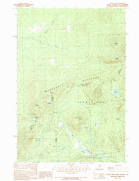
1989 Map of Moose Bog
USGS Topo · Published 1989About this map
The Magalloway River system flows through this remote borderland at the edge of Maine and New Hampshire, where the International Boundary meets the Canada United States line. The terrain is defined by the high elevations of the Montagnes Blanches, featuring prominent peaks such as Mount D'Urban and Saddle Hill. In the late 1980s, this area remained largely undeveloped forest and marshland, with drainage systems including Moose Bog Brook and the West Branch feeding into the larger river valley.
Find a feature on this map
28 named features on this map. Tap any name to fly to it.
Don’t see what you’re looking for? This feature index may not catch every label — zoom into the map to look around manually.
Map Details
Editions of this 1989 Moose Bog Map
This is the sole edition of this map. No revisions or reprints were ever made.
Other maps of this area

1927 · Moose Bog
USGS Topo · 1:48,000

1927 · Second Lake
USGS Topo · 1:62,500

1931 · Cupsuptic
USGS Topo · 1:48,000

1931 · Moose Bog
USGS Topo · 1:62,500

1932 · Second Lake
USGS Topo · 1:62,500

1932 · Arnold Pond
USGS Topo · 1:48,000

1934 · Cupsuptic
USGS Topo · 1:62,500

1935 · Cupsuptic
USGS Topo · 1:62,500

1935 · Arnold Pond
USGS Topo · 1:62,500

1949 · Jackman
USGS Topo · 1:250,000