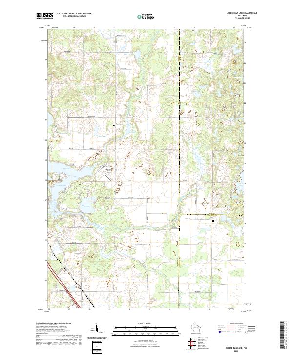
2022 Map of Moose Ear Lake
USGS Topo · Published 2022About this map
Moose Ear Lake and the surrounding glacial terrain define this portion of Barron County, where complex waterways connect into the larger Lake Chetek system. The landscape is characterized by a dense network of kettle lakes and meandering streams, including Tenmile Creek and Beaver Creek, which drain toward the larger reservoirs to the west. Evidence of rural life and local history is anchored by sites like the Johnson Cem and the Twin Lakes Cem, located near the tri-county boundary where Barron, Rusk, and Chippewa counties meet. Smaller bodies of water such as Koehler Lake, Jacobson Lake, and Beauty Lake are scattered among a grid of section-line roads, illustrating the persistent agricultural and recreational character of the region. The inclusion of the Cloud Dancer Private Airport near the northern reaches of Tenmile Lake highlights the modern aviation presence in this otherwise quiet lake country.
Find a feature on this map
87 named features on this map. Tap any name to fly to it.
Don’t see what you’re looking for? This feature index may not catch every label — zoom into the map to look around manually.
Map Details
Editions of this 2022 Moose Ear Lake Map
This is the sole edition of this map. No revisions or reprints were ever made.
Other maps of this area

1948 · Weyerhauser
USGS Topo · 1:48,000

1949 · Bloomer
USGS Topo · 1:62,500

1949 · New Auburn
USGS Topo · 1:62,500

1950 · Weyerhauser
USGS Topo · 1:48,000

1951 · Bloomer
USGS Topo · 1:62,500

1951 · New Auburn
USGS Topo · 1:62,500

1951 · Chetek
USGS Topo · 1:62,500

1953 · Rice Lake
USGS Topo · 1:250,000

1959 · Rice Lake
USGS Topo · 1:250,000
1972 · Chain Lake
USGS Topo · 1:24,000