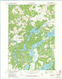
1972 Map of Chain Lake
USGS Topo · Published 1974About this map
Glacial lakes and wetlands define the borderlands of Rusk Co Chippewa Co in this early 1970s topographic study. The landscape is dominated by an intricate network of waterways including the Axhandle Lakes and the central passage known as The Narrows. At the northern edge, Two Bear Camp serves as a remote outpost near Two Bear Lake, while the Stang Lookout Tower provides a strategic high point overlooking the dense woods of Big Bend and Sampson. The presence of the State Wildlife Management Area and Morris-Erickson County Park indicates a region deeply committed to conservation and outdoor recreation. A small Gravel Pit and a local Townhall mark the sparse human footprint among named roads like Sugar Lake Road and Plummer Road.
Find a feature on this map
75 named features on this map. Tap any name to fly to it.
Don’t see what you’re looking for? This feature index may not catch every label — zoom into the map to look around manually.
Map Details
Editions of this 1972 Chain Lake Map
This is the sole edition of this map. No revisions or reprints were ever made.
Other maps of this area

1948 · Weyerhauser
USGS Topo · 1:48,000

1949 · Bloomer
USGS Topo · 1:62,500

1949 · New Auburn
USGS Topo · 1:62,500

1950 · Weyerhauser
USGS Topo · 1:48,000

1951 · Bloomer
USGS Topo · 1:62,500

1951 · New Auburn
USGS Topo · 1:62,500

1951 · Chetek
USGS Topo · 1:62,500

1953 · Rice Lake
USGS Topo · 1:250,000

1959 · Rice Lake
USGS Topo · 1:250,000
1972 · Fireside Lakes
USGS Topo · 1:24,000