
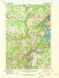
1961 Map of Moose Lake
USGS Topo · Published 1963About this map
The Kettle River winds southward through this 1960s landscape, anchoring a series of small riverside and lakeside communities in Carlton and Pine counties. The town of Moose Lake serves as a primary hub in the northeast, featuring the Moose Lake Airport and the large State Hospital complex near the shores of Moosehead Lake. To the south, the General C C Andrews State Forest covers a significant portion of the terrain, interspersed with numerous water bodies like Sturgeon Lake and Island Lake.
Find a feature on this map
66 named features on this map. Tap any name to fly to it.
Don’t see what you’re looking for? This feature index may not catch every label — zoom into the map to look around manually.
Map Details
Editions of this 1961 Moose Lake Map
2 editions found
Other maps of this area

1953 · Duluth
USGS Topo · 1:250,000

1956 · Barnum
USGS Topo · 1:62,500

1958 · Duluth
USGS Topo · 1:250,000

1961 · Sandstone
USGS Topo · 1:62,500

1961 · Cromwell
USGS Topo · 1:62,500

1962 · Bruno
USGS Topo · 1:62,500

1962 · Cloverdale
USGS Topo · 1:62,500

1968 · Giese
USGS Topo · 1:24,000

1969 · Arthyde
USGS Topo · 1:24,000

1969 · Ronald
USGS Topo · 1:24,000