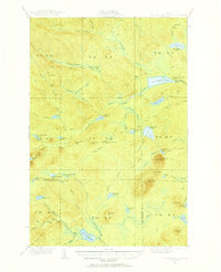
1931 Map of Mooseleuk Lake
USGS Topo · Published 1956About this map
The remote forestlands of northern Maine's Aroostook and Piscataquis counties are defined here by a network of logging camps and waterways recorded during a 1931 survey. Mooseleuk Lake and Big Machias Lake anchor a landscape dominated by timber interests, as evidenced by the American Realty holdings. Dozens of seasonal outposts such as Goulds Camp, Storms Camp, and Pratt Lake Camp are scattered throughout the townships, connected by rudimentary paths like the Tote Road and the Mtn Trail. This survey captures the working wilderness before the modernization of forest management, where fire prevention was monitored from the Fire Tower atop Round Mtn. The detailed topography tracks the complex drainage systems of the Machias River and Twentyfivemile Brook, essential for the era's log driving operations.
Find a feature on this map
77 named features on this map. Tap any name to fly to it.
Don’t see what you’re looking for? This feature index may not catch every label — zoom into the map to look around manually.
Map Details
Editions of this 1931 Mooseleuk Lake Map
2 editions found
Other maps of this area

1928 · Winterville
USGS Topo · 1:48,000

1930 · Greenlaw
USGS Topo · 1:48,000

1931 · Fish River Lake
USGS Topo · 1:48,000

1931 · Mooseleuk Lake
USGS Topo · 1:48,000

1931 · Winterville
USGS Topo · 1:62,500

1932 · Musquacook Lakes
USGS Topo · 1:48,000

1932 · Allagash Falls
USGS Topo · 1:48,000

1933 · Greenlaw
USGS Topo · 1:62,500

1935 · Musquacook Lakes
USGS Topo · 1:62,500

1935 · Fish River Lake
USGS Topo · 1:62,500