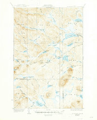
1935 Map of Mooseleuk Lake
USGS Topo · Published 1947About this map
The remote lumbering and sporting camps of northern Aroostook County are documented here during the early 1930s. The landscape is defined by a dense network of water bodies, including Big Machias Lake and Mooseleuk Lake, which supported the region's early 20th-century economies. Temporary settlements such as Goulds Camp and Storms Camp are scattered along the major waterways, often connected by primitive routes like the Tote Road. A Fire Tower atop Round Mtn served as a critical lookout point for the vast timberlands. The survey illustrates the complex drainage system of the North Maine Woods, where Twentyfivemile Brook and Clayton Stream flow through townships defined by a rigid grid of survey lines, such as T 11 R 9, reflecting the administrative management of this wilderness territory.
Find a feature on this map
76 named features on this map. Tap any name to fly to it.
Don’t see what you’re looking for? This feature index may not catch every label — zoom into the map to look around manually.
Map Details
Editions of this 1935 Mooseleuk Lake Map
3 editions found

Other maps of this area

1928 · Winterville
USGS Topo · 1:48,000

1930 · Greenlaw
USGS Topo · 1:48,000

1931 · Fish River Lake
USGS Topo · 1:48,000

1931 · Mooseleuk Lake
USGS Topo · 1:48,000

1931 · Winterville
USGS Topo · 1:62,500

1932 · Musquacook Lakes
USGS Topo · 1:48,000

1932 · Allagash Falls
USGS Topo · 1:48,000

1933 · Greenlaw
USGS Topo · 1:62,500

1935 · Musquacook Lakes
USGS Topo · 1:62,500

1935 · Fish River Lake
USGS Topo · 1:62,500