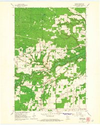
1964 Map of Moquah
USGS Topo · Published 1965About this map
Chequamegon National Forest dominates the northern landscape of this mid-1960s survey, where the heavy timber transitions into the headwaters of the Lake Superior basin. The rail infrastructure of Bayfield County is clearly delineated, showing the Northern Pacific and Chicago and North Western lines alongside an Old Railroad Grade that speaks to earlier logging eras. Small rural hubs like Moquah and Benoit anchor the local community, supported by landmarks such as St Peters Ch and a small Cem. Numerous Gravel Pits and Sandpits are scattered throughout the townships of Pilsen and Keystone, indicating the local extraction industry that served road and rail maintenance. The intricate drainage patterns of Whittlesey Creek, Fish Creek, and their various forks illustrate the complex hydrology of the region as water flows toward the Great Lakes.
Find a feature on this map
27 named features on this map. Tap any name to fly to it.
Don’t see what you’re looking for? This feature index may not catch every label — zoom into the map to look around manually.
Map Details
Editions of this 1964 Moquah Map
2 editions found
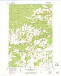
Other maps of this area

1942 · Ashland
USGS Topo · 1:48,000

1942 · Marengo
USGS Topo · 1:48,000

1944 · Moquah
USGS Topo · 1:48,000

1944 · Grandview
USGS Topo · 1:48,000

1945 · Marengo
USGS Topo · 1:48,000

1947 · Moquah
USGS Topo · 1:48,000

1947 · Ashland
USGS Topo · 1:48,000

1947 · Grandview
USGS Topo · 1:48,000

1953 · Ashland
USGS Topo · 1:250,000

1958 · Ashland
USGS Topo · 1:250,000