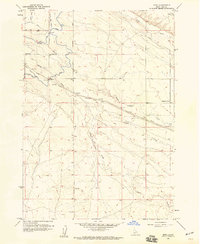
1958 Map of Mora
USGS Topo · Published 1959About this map
Mora sits at a critical junction of rail and water in this late 1950s landscape of Ada County. The Union Pacific (Oregon Short Line) Railroad cuts a diagonal path through the terrain, passing through Mora and following the general course of Indian Creek. This area illustrates the complex irrigation network vital to Idaho's development, featuring the Kuna Canal, the Mason Creek Feeder, and the Hubbard Lateral. These man-made channels diverge from natural waterways like North Indian Creek and Tenmile Creek to support the agricultural potential of the high desert plains. To the east, the landscape transitions into more open country toward Pleasant Valley, while the southern reaches are defined by the intermittent flows of Sand Creek. The map documents a moment when local transportation was managed via the Mora Road and Bennett Road, reflecting a rural infrastructure built around the railroad's presence.
Find a feature on this map
33 named features on this map. Tap any name to fly to it.
Don’t see what you’re looking for? This feature index may not catch every label — zoom into the map to look around manually.
Map Details
Editions of this 1958 Mora Map
3 editions found
Other maps of this area

1892 · Boise
USGS Topo · 1:125,000

1892 · Bisuka
USGS Topo · 1:125,000

1894 · Bisuka
USGS Topo · 1:125,000

1897 · Boise
USGS Topo · 1:125,000

1953 · Cloverdale
USGS Topo · 1:24,000

1953 · Meridian
USGS Topo · 1:24,000

1954 · Boise South
USGS Topo · 1:24,000

1954 · Boise
USGS Topo · 1:62,500

1955 · Christmas Mtn
USGS Topo · 1:24,000
1955 · Coyote Butte
USGS Topo · 1:24,000