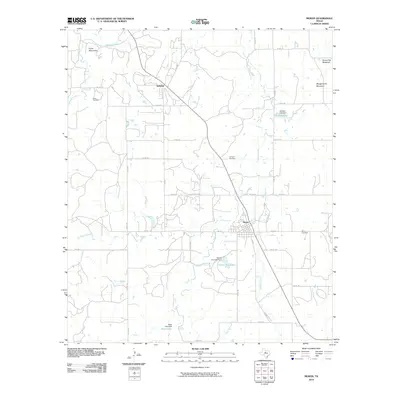
2010 Map of Moran
USGS Topo · Published 2010About this map
Moran anchors the southeastern portion of this West Texas survey, serving as a hub for a network of country roads including FM 576, FM 880, and FM 2408. The landscape is characterized by intermittent drainage systems such as Post Oak Creek and Deep Creek, which feed into several small reservoirs like Moran City Lake and Johnson Lake. To the north, the small settlement of Sedwick sits along a primary road corridor, while the terrain rises into prominent landmarks such as the Greer Mountains and Mugginsville Mountain. Family history and local heritage are well-preserved through several burial sites, including Greer Cemetery, Johnson Cemetery, and the Moran Cemetery located east of town. The mapping of various dams, such as the Wylie Lake Dam, illustrates the essential role of water management in this agricultural and ranching environment.
Find a feature on this map
41 named features on this map. Tap any name to fly to it.
Don’t see what you’re looking for? This feature index may not catch every label — zoom into the map to look around manually.
Map Details
Editions of this 2010 Moran Map
This is the sole edition of this map. No revisions or reprints were ever made.
Other maps of this area

1892 · Albany
USGS Topo · 1:125,000

1893 · Albany
USGS Topo · 1:125,000

1931 · Baird
USGS Topo · 1:125,000

1932 · Baird
USGS Topo · 1:125,000

1954 · Abilene
USGS Topo · 1:250,000

1958 · Abilene
USGS Topo · 1:250,000

1961 · Eolian
USGS Topo · 1:24,000

1965 · Albany
USGS Topo · 1:24,000

1965 · McCatherine Mountain
USGS Topo · 1:24,000
1965 · Snyder Lake
USGS Topo · 1:24,000