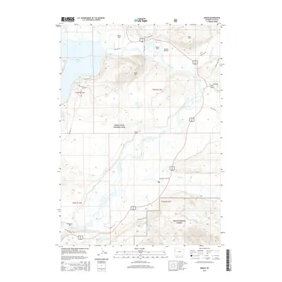
2015 Map of Moran
USGS Topo · Published 2015About this map
Moran and Elk anchor the eastern and central portions of this 2015 study, situated where the high valley meets the protected wilderness of Grand Teton National Park. The Snake River dominates the landscape, forming the famous Oxbow Bend near Buffalo Meadow before flowing south past Deadmans Bar. The map provides significant detail for those tracing the road and trail networks of the modern park era, including the Signal Mountain Rd ascending to Signal Mtn and the Triangle X Ranch Rd leading into the foothills of the Teton National Forest. Large wetland features such as Willow Flats and Christian Pond illustrate the complex hydrology of the Jackson Hole valley floor, while the surrounding peaks like Lozier Hill define the topographic boundaries between the park and the national forest.
Find a feature on this map
40 named features on this map. Tap any name to fly to it.
Don’t see what you’re looking for? This feature index may not catch every label — zoom into the map to look around manually.
Map Details
Editions of this 2015 Moran Map
This is the sole edition of this map. No revisions or reprints were ever made.
Other maps of this area

1899 · Grand Teton
USGS Topo · 1:125,000

1901 · Grand Teton
USGS Topo · 1:125,000

1902 · Mt Leidy
USGS Topo · 1:125,000

1955 · Driggs
USGS Topo · 1:250,000

1958 · Driggs
USGS Topo · 1:250,000

1962 · Driggs
USGS Topo · 1:250,000

1965 · Davis Hill
USGS Topo · 1:24,000

1965 · Mount Leidy
USGS Topo · 1:24,000
1965 · Whetstone Mountain
USGS Topo · 1:24,000

1968 · Moose
USGS Topo · 1:24,000