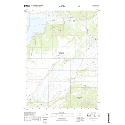
2017 Map of Moran
USGS Topo · Published 2017About this map
Snake River corridors and the expansive wetlands of Willow Flats dominate this 2017 survey of the Teton valley. The landscape is a transition between Grand Teton National Park and the Teton National Forest, characterized by the braiding channels of Spread Cr and the Buffalo Fork. Local history is anchored by sites like Cunningham Cabin and the Allen Cem, located near the northern edge of the sheet. The terrain rises sharply from the valley floor to the summit of Signal Mtn, providing a vantage point over Jackson Lake and the various ranch roads, such as Elk Ranch Road and Wolff Ranch Road, that crisscross the sagebrush flats and meadows. This record captures the complex network of federal lands and historical ranching markers before recent environmental shifts in the Greater Yellowstone Ecosystem.
Find a feature on this map
46 named features on this map. Tap any name to fly to it.
Don’t see what you’re looking for? This feature index may not catch every label — zoom into the map to look around manually.
Map Details
Editions of this 2017 Moran Map
This is the sole edition of this map. No revisions or reprints were ever made.
Other maps of this area

1899 · Grand Teton
USGS Topo · 1:125,000

1901 · Grand Teton
USGS Topo · 1:125,000

1902 · Mt Leidy
USGS Topo · 1:125,000

1955 · Driggs
USGS Topo · 1:250,000

1958 · Driggs
USGS Topo · 1:250,000

1962 · Driggs
USGS Topo · 1:250,000

1965 · Davis Hill
USGS Topo · 1:24,000

1965 · Mount Leidy
USGS Topo · 1:24,000
1965 · Whetstone Mountain
USGS Topo · 1:24,000

1968 · Moose
USGS Topo · 1:24,000