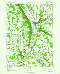
1943 Map of Moravia
USGS Topo · Published 1961About this map
Owasco Inlet carves a deep path through this Cayuga County landscape, flanked by the steep slopes of Owasco Hill and Jewett Hill. The valley floor is dominated by the Owasco Flats and the village of Moravia, where the Lehigh Valley railroad and Mill Creek converge. The waterway's descent from the surrounding uplands creates dramatic features like Parsons Falls and Montville Falls near the village of Montville.
Find a feature on this map
52 named features on this map. Tap any name to fly to it.
Don’t see what you’re looking for? This feature index may not catch every label — zoom into the map to look around manually.
Map Details
Editions of this 1943 Moravia Map
3 editions found

Other maps of this area

1898 · Moravia
USGS Topo · 1:62,500

1899 · Auburn
USGS Topo · 1:62,500

1899 · Skaneateles
USGS Topo · 1:62,500

1902 · Skaneateles
USGS Topo · 1:62,500

1902 · Moravia
USGS Topo · 1:62,500

1902 · Genoa
USGS Topo · 1:62,500

1902 · Auburn
USGS Topo · 1:62,500

1942 · Ludlowville
USGS Topo · 1:24,000

1942 · Groton
USGS Topo · 1:24,000

1942 · Genoa
USGS Topo · 1:24,000