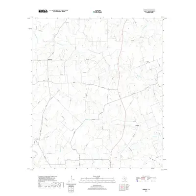
2019 Map of Moravia
USGS Topo · Published 2019About this map
Moravia and the surrounding Lavaca County countryside appear here as a landscape defined by an intricate network of creeks and branches that feed the regional river systems. The settlement pattern is largely rural, anchored by small communities like Breslau and Kinkler. These pockets of habitation are linked by a dense web of county roads and farm-to-market routes, such as FM 532, which traverse the undulating terrain toward the Lavaca River in the southwest and the W Navidad River in the northeast.
Find a feature on this map
72 named features on this map. Tap any name to fly to it.
Don’t see what you’re looking for? This feature index may not catch every label — zoom into the map to look around manually.
Map Details
Editions of this 2019 Moravia Map
This is the sole edition of this map. No revisions or reprints were ever made.
Other maps of this area

1901 · Flatonia
USGS Topo · 1:125,000

1919 · Schulenburg
USGS Topo · 1:62,500

1953 · Seguin
USGS Topo · 1:250,000

1958 · Seguin
USGS Topo · 1:250,000

1962 · Sublime
USGS Topo · 1:24,000

1962 · Hallettsville
USGS Topo · 1:24,000

1965 · Oakland
USGS Topo · 1:24,000
1965 · Weimar
USGS Topo · 1:24,000

1965 · Schulenburg
USGS Topo · 1:24,000

1965 · Wied
USGS Topo · 1:24,000