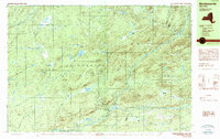
1989 Map of Morehouseville
USGS Topo · Published 1989About this map
Morehouseville and Nobleboro stand as small interior settlements within the vast Adirondack Park at the edge of Herkimer and Hamilton counties. Surveyed in the late 1980s, this terrain is defined by a dense network of high-elevation wetlands and family-named peaks, including McCauley Mountain and Fort Noble Mtn. Water features dominate the landscape, from the expansive Black Creek Lake and Mill Creek Lake to smaller basins like Burp Lake and Finches Pond. The presence of numerous vlys, such as Whiskey Spring Vly and Bethune Vly, points to a landscape shaped by beaver activity and slow-draining glacial depressions. Transportation is limited to a few improved routes like South Branch, reflecting the remote character of these mountain communities during the late twentieth century.
Find a feature on this map
60 named features on this map. Tap any name to fly to it.
Don’t see what you’re looking for? This feature index may not catch every label — zoom into the map to look around manually.
Map Details
Editions of this 1989 Morehouseville Map
2 editions found
Other maps of this area

1897 · Remsen
USGS Topo · 1:62,500

1900 · Remsen
USGS Topo · 1:62,500

1900 · Canada Lake
USGS Topo · 1:62,500

1900 · Wilmurt
USGS Topo · 1:62,500

1901 · Old Forge
USGS Topo · 1:62,500

1902 · Wilmurt
USGS Topo · 1:62,500

1903 · West Canada Lakes
USGS Topo · 1:62,500

1904 · Piseco Lake
USGS Topo · 1:62,500

1906 · Piseco Lake
USGS Topo · 1:62,500

1908 · Piseco Lake
USGS Topo · 1:62,500