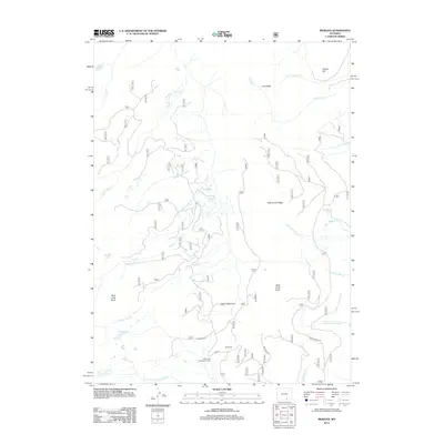
2012 Map of Morgan
USGS Topo · Published 2012About this map
Rock Creek Ridge and Cooper Hill define this high-altitude landscape in the Snowy Range area, where a dense network of Forest Service routes like Usfs RD 320 and Usfs RD 328 navigate the steep drainage systems. The map detail reflects a wilderness of subalpine lakes and creek forks, including North Twin Lakes, Snow Bank Lake, and the remote Crater Lake. Human interaction with the terrain is evidenced through recreational and administrative sites such as Rock Creek Park and Clark Park, while North Fork Observation Point offers a strategic vantage over the complex hydrology of the N Fork Little Laramie River. This survey captures the intricate headwaters where numerous small streams, such as Sevenmile Cr and N Fork Mill Cr, begin their descent through the Medicine Bow National Forest.
Find a feature on this map
77 named features on this map. Tap any name to fly to it.
Don’t see what you’re looking for? This feature index may not catch every label — zoom into the map to look around manually.
Map Details
Editions of this 2012 Morgan Map
This is the sole edition of this map. No revisions or reprints were ever made.
Other maps of this area

1906 · Medicine Bow
USGS Topo · 1:125,000

1908 · Medicine Bow
USGS Topo · 1:125,000

1954 · Rawlins
USGS Topo · 1:250,000

1958 · Rawlins
USGS Topo · 1:250,000

1958 · White Rock Canyon
USGS Topo · 1:24,000

1958 · Bengough Hill
USGS Topo · 1:24,000

1958 · Arlington
USGS Topo · 1:24,000

1961 · Sand Lake
USGS Topo · 1:24,000
1961 · Strouss Hill
USGS Topo · 1:24,000

1961 · Medicine Bow Peak
USGS Topo · 1:24,000