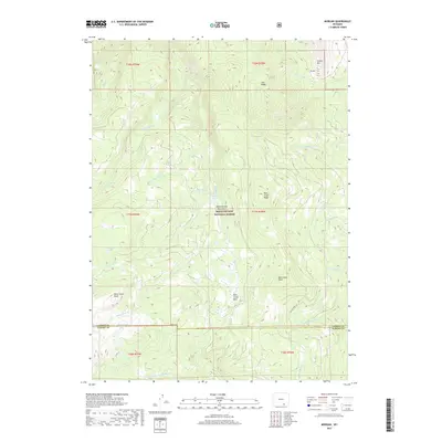
2017 Map of Morgan
USGS Topo · Published 2017About this map
The Medicine Bow National Forest dominates this section of the Medicine Bow Mountains, where high-elevation terrain is defined by a complex network of glacial lakes and creek drainages. Significant summits and ridgelines like Cooper Hill, Lulu Ridge, and Rock Creek Ridge create a dramatic topography, dropping into sheltered areas such as Rock Creek Park. This 2017 survey details the hydrology of the Laramie Range's western reaches, capturing the headwaters of the N Fork Little Laramie River and several namesake branches of Rock Creek.
Find a feature on this map
32 named features on this map. Tap any name to fly to it.
Don’t see what you’re looking for? This feature index may not catch every label — zoom into the map to look around manually.
Map Details
Editions of this 2017 Morgan Map
This is the sole edition of this map. No revisions or reprints were ever made.
Other maps of this area

1906 · Medicine Bow
USGS Topo · 1:125,000

1908 · Medicine Bow
USGS Topo · 1:125,000

1954 · Rawlins
USGS Topo · 1:250,000

1958 · Rawlins
USGS Topo · 1:250,000

1958 · White Rock Canyon
USGS Topo · 1:24,000

1958 · Bengough Hill
USGS Topo · 1:24,000

1958 · Arlington
USGS Topo · 1:24,000

1961 · Sand Lake
USGS Topo · 1:24,000
1961 · Strouss Hill
USGS Topo · 1:24,000

1961 · Medicine Bow Peak
USGS Topo · 1:24,000