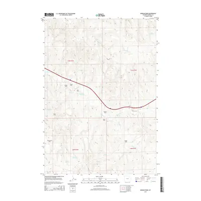
2015 Map of Morgan Draw
USGS Topo · Published 2015About this map
Hydraulic engineering and drainage patterns define this Campbell County landscape, where numerous man-made catchments have been established to manage the arid high plains. The terrain is marked by a complex network of draws, most notably Morgan Draw and Pearson Draw, which channel seasonal runoff toward larger creek systems. These draws are punctuated by several small bodies of water, including Punkie Reservoir, Dead Horse Reservoir, and Karen Reservoir, suggesting a landscape primarily focused on supporting livestock and managing the intermittent flow of Dead Horse Cr. Remote ranch access is provided via Barber Creek Rd and Napier Rd, which traverse the undulating topography between Township 49 North Range 76 West and Township 48 North Range 75 West.
Find a feature on this map
23 named features on this map. Tap any name to fly to it.
Don’t see what you’re looking for? This feature index may not catch every label — zoom into the map to look around manually.
Map Details
Editions of this 2015 Morgan Draw Map
This is the sole edition of this map. No revisions or reprints were ever made.
Other maps of this area

1954 · Gillette
USGS Topo · 1:250,000

1955 · Sheridan
USGS Topo · 1:250,000

1955 · Gillette
USGS Topo · 1:250,000

1958 · Gillette
USGS Topo · 1:250,000

1958 · Sheridan
USGS Topo · 1:250,000

1962 · Gillette
USGS Topo · 1:250,000

1962 · Sheridan
USGS Topo · 1:250,000
1971 · Double Tanks
USGS Topo · 1:24,000
1971 · Scott Dam
USGS Topo · 1:24,000
1971 · Bogie Draw
USGS Topo · 1:24,000