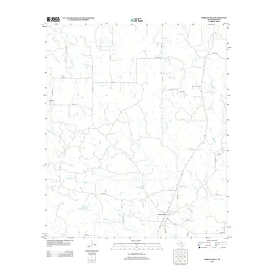
2012 Map of Morgan Mill
USGS Topo · Published 2012About this map
Morgan Mill and the surrounding rangelands of Erath County are documented in this 2012 USGS topographic survey. The landscape is defined by an intricate network of waterways draining into the N Paluxy River, which meanders across the southern portion of the quadrangle. Tributaries like Big Sunday Cr, Bear Cr, and Germany Cr carve through the terrain, illustrating the region's natural drainage patterns. To the northwest, the settlement of Sapoak sits near the intersection of several county roads, while the Hightower Cem provides a point of interest for genealogists researching local families. The map details a transition from rural farmland to more developed corridors, particularly along FM-1188 and FM-1189. This edition serves as a precise record of the road network in the early 21st century, featuring numerous labeled county roads such as Patilla Ridge Rd and Robinson Rd that connect the scattered homesteads and agricultural plots throughout the region.
Find a feature on this map
40 named features on this map. Tap any name to fly to it.
Don’t see what you’re looking for? This feature index may not catch every label — zoom into the map to look around manually.
Map Details
Editions of this 2012 Morgan Mill Map
This is the sole edition of this map. No revisions or reprints were ever made.
Other maps of this area

1890 · Stephenville
USGS Topo · 1:125,000

1891 · Palo Pinto
USGS Topo · 1:125,000

1918 · Palo Pinto
USGS Topo · 1:125,000

1920 · Stephenville
USGS Topo · 1:125,000

1931 · Santo
USGS Topo · 1:62,500

1954 · Abilene
USGS Topo · 1:250,000

1958 · Abilene
USGS Topo · 1:250,000
1959 · Lipan
USGS Topo · 1:62,500

1959 · Gordon
USGS Topo · 1:62,500

1961 · Knob Hill
USGS Topo · 1:24,000