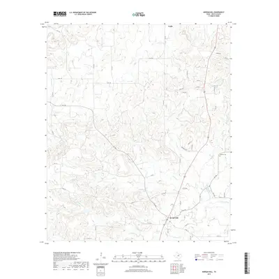
2019 Map of Morgan Mill
USGS Topo · Published 2019About this map
Morgan Mill serves as a central hub in this section of Erath County, where the intersection of US Hwy 281 and several farm-to-market roads defines the local transit pattern. The landscape is characterized by a dense network of seasonal drainages and creeks, including Counts Cr, Germany Cr, and Bee Dee Cr, which all feed toward the N Paluxy River in the southern reaches of the quadrangle. In the northeast, the settlement of Patillo sits near the headwaters of Buck Cr. The presence of the Hightower Cem near the eastern border provides a significant point of interest for those researching local family histories and early burials in this rural corridor. This modern survey illustrates how long-standing ranch roads like Co RD 132 and Co RD 140 continue to follow the natural contours of the Erath County terrain.
Find a feature on this map
53 named features on this map. Tap any name to fly to it.
Don’t see what you’re looking for? This feature index may not catch every label — zoom into the map to look around manually.
Map Details
Editions of this 2019 Morgan Mill Map
This is the sole edition of this map. No revisions or reprints were ever made.
Other maps of this area

1890 · Stephenville
USGS Topo · 1:125,000

1891 · Palo Pinto
USGS Topo · 1:125,000

1918 · Palo Pinto
USGS Topo · 1:125,000

1920 · Stephenville
USGS Topo · 1:125,000

1931 · Santo
USGS Topo · 1:62,500

1954 · Abilene
USGS Topo · 1:250,000

1958 · Abilene
USGS Topo · 1:250,000
1959 · Lipan
USGS Topo · 1:62,500

1959 · Gordon
USGS Topo · 1:62,500

1961 · Knob Hill
USGS Topo · 1:24,000