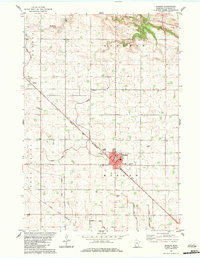
1983 Map of Morgan
USGS Topo · Published 1983About this map
The city of Morgan sits at the intersection of local industry and rural heritage in this early 1980s Redwood County landscape. Bisecting the region, the Chicago and North Western railway serves as a central artery, passing through the town and connecting it to outlying points like Gilfillan. The land is defined by sophisticated water management, with numerous drainage works such as Judicial Ditch No 109 and Judicial Ditch No 30 crisscrossing the townships of Sherman and Three Lakes.
Find a feature on this map
24 named features on this map. Tap any name to fly to it.
Don’t see what you’re looking for? This feature index may not catch every label — zoom into the map to look around manually.
Map Details
Editions of this 1983 Morgan Map
This is the sole edition of this map. No revisions or reprints were ever made.
Other maps of this area

1952 · Morton
USGS Topo · 1:62,500

1952 · Redwood Falls
USGS Topo · 1:62,500

1953 · Morgan
USGS Topo · 1:62,500

1953 · New Ulm
USGS Topo · 1:250,000

1957 · New Ulm
USGS Topo · 1:250,000

1958 · New Ulm
USGS Topo · 1:250,000

1967 · New Ulm
USGS Topo · 1:250,000

1967 · Clements
USGS Topo · 1:24,000

1967 · Clements SE
USGS Topo · 1:24,000
1982 · Morgan NE
USGS Topo · 1:24,000