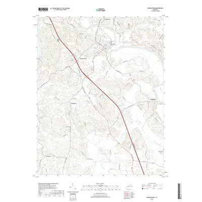
2019 Map of Morgantown
USGS Topo · Published 2019About this map
The Green River snakes through the northern and eastern portions of this landscape, anchoring the settlements of Aberdeen and Woodbury. The town of Morgantown serves as a central hub where Rochester RD and Bowling Green RD converge. The terrain is defined by deeply cut drainages such as Deer Lick Hollow and Stillhouse Hollow, which create a complex system of ridges like Hagan Shanty Ridge and Allens Hill. Local history is preserved in numerous family and community burial grounds, including Wade Cem, Cook Cem, and Newton Cem. To the south, smaller communities such as Youngtown and Leetown are situated near the headwaters of Sandy Cr and Little Muddy Cr, reflecting a dispersed settlement pattern tied to the region's diverse topography and narrow creek bottoms.
Find a feature on this map
83 named features on this map. Tap any name to fly to it.
Don’t see what you’re looking for? This feature index may not catch every label — zoom into the map to look around manually.
Map Details
Editions of this 2019 Morgantown Map
This is the sole edition of this map. No revisions or reprints were ever made.
Other maps of this area

1909 · Hartford
USGS Topo · 1:62,500

1911 · Dunmor
USGS Topo · 1:48,000

1914 · Little Muddy
USGS Topo · 1:62,500

1914 · Dunmor
USGS Topo · 1:62,500

1925 · Spring Lick
USGS Topo · 1:62,500

1953 · South Hill
USGS Topo · 1:24,000

1953 · Quality
USGS Topo · 1:24,000

1954 · Evansville
USGS Topo · 1:250,000

1954 · Welchs Creek
USGS Topo · 1:24,000
1954 · Cromwell
USGS Topo · 1:24,000