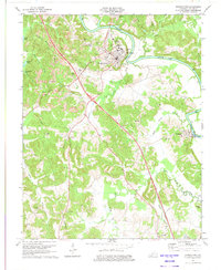
1973 Map of Morgantown
USGS Topo · Published 1974About this map
The Green River carves a sweeping path through the heart of Butler County, anchoring the commercial and residential hubs of Morgantown and Woodbury. This 1973 survey illustrates a landscape defined by traditional river-bend settlements and the mid-century expansion of the Green River Parkway, which cuts a straight line through the winding terrain. Near the confluence of Welch Creek and Sandy Creek, the area shows significant industrial activity with numerous Strip Mines and a Quarry operating on the outskirts of town.
Find a feature on this map
50 named features on this map. Tap any name to fly to it.
Don’t see what you’re looking for? This feature index may not catch every label — zoom into the map to look around manually.
Map Details
Editions of this 1973 Morgantown Map
This is the sole edition of this map. No revisions or reprints were ever made.
Other maps of this area

1909 · Hartford
USGS Topo · 1:62,500

1911 · Dunmor
USGS Topo · 1:48,000

1914 · Little Muddy
USGS Topo · 1:62,500

1914 · Dunmor
USGS Topo · 1:62,500

1925 · Spring Lick
USGS Topo · 1:62,500

1953 · South Hill
USGS Topo · 1:24,000

1953 · Quality
USGS Topo · 1:24,000

1954 · Evansville
USGS Topo · 1:250,000

1954 · Welchs Creek
USGS Topo · 1:24,000
1954 · Cromwell
USGS Topo · 1:24,000