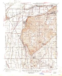
1934 Map of Morley
USGS Topo · Published 1946About this map
The Headwater Diversion Channel dominates the northern landscape of this Scott County region, a massive engineering feat designed to redirect floodwaters away from the Mississippi River lowlands. The map reveals a complex web of drainage infrastructure, including the Cape Girardeau Ditch and numerous numbered laterals like Ditch No 17, which fundamentally transformed the local ecology to support agriculture. In this mid-century period, the area is a crossroads of significant rail lines, with the Missouri Pacific, St Louis San Francisco, and St Louis Southwestern railroads converging near the industrial hubs of Chaffee and Illmo. Away from the rail corridors, the terrain transitions into the Moreland hills, where smaller rural communities like New Hamburg and Benton are situated. Numerous country schools, such as Rebel Sch and Hooe Sch, provide a detailed look at the era's decentralized educational system and rural settlement patterns.
Find a feature on this map
65 named features on this map. Tap any name to fly to it.
Don’t see what you’re looking for? This feature index may not catch every label — zoom into the map to look around manually.
Map Details
Editions of this 1934 Morley Map
3 editions found
Other maps of this area

1920 · Jonesboro
USGS Topo · 1:62,500

1922 · Cape Girardeau
USGS Topo · 1:62,500

1923 · Jonesboro
USGS Topo · 1:62,500

1924 · Cape Girardeau
USGS Topo · 1:62,500

1931 · Sikeston
USGS Topo · 1:62,500

1933 · Marble Hill
USGS Topo · 1:62,500

1934 · Thebes
USGS Topo · 1:62,500

1934 · Morley
USGS Topo · 1:62,500

1934 · Bloomfield
USGS Topo · 1:62,500

1934 · Sikeston
USGS Topo · 1:62,500