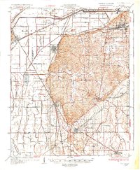
1934 Map of Morley
USGS Topo · Published 1934About this map
Benton serves as a focal point for this 1934 study of Scott County, Missouri, situated at a junction of regional roads and rails just as the landscape was being profoundly altered by civil engineering. The map reveals an extensive and complex drainage network, including the Headwater Diversion Channel and numerous numbered ditches like Cape Girardeau No 17 Ditch, reflecting a period of major land reclamation that transformed the swampy lowlands of the Sylvania and Moreland districts into productive agricultural territory. The rail infrastructure is particularly dense, with the Missouri Pacific RR, St Louis San Francisco RR, and St Louis Southwestern RR all intersecting near industrial hubs like Chaffee and Rockview. Local genealogists will find several rural schools preserved in these records, such as Pleasant Hill Sch and Debol Sch, which anchored the small farming communities of the early 20th century.
Find a feature on this map
112 named features on this map. Tap any name to fly to it.
Don’t see what you’re looking for? This feature index may not catch every label — zoom into the map to look around manually.
Map Details
Editions of this 1934 Morley Map
3 editions found
Other maps of this area

1920 · Jonesboro
USGS Topo · 1:62,500

1922 · Cape Girardeau
USGS Topo · 1:62,500

1923 · Jonesboro
USGS Topo · 1:62,500

1924 · Cape Girardeau
USGS Topo · 1:62,500

1931 · Sikeston
USGS Topo · 1:62,500

1933 · Marble Hill
USGS Topo · 1:62,500

1934 · Thebes
USGS Topo · 1:62,500

1934 · Morley
USGS Topo · 1:62,500

1934 · Bloomfield
USGS Topo · 1:62,500

1934 · Sikeston
USGS Topo · 1:62,500