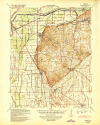
1939 Map of Morley
USGS Topo · Published 1943About this map
Scott County, Missouri, is defined here by a massive hydraulic engineering network, where the Headwater Diversion Channel and a complex system of numbered ditches, such as Ditch No 12 and Ditch No 1, have transformed the lowland terrain. This intricate drainage effort supported the growth of railroad-centric towns like Chaffee and Morley along the St Louis San Francisco and Missouri Pacific lines.
Find a feature on this map
76 named features on this map. Tap any name to fly to it.
Don’t see what you’re looking for? This feature index may not catch every label — zoom into the map to look around manually.
Map Details
Editions of this 1939 Morley Map
2 editions found

Other maps of this area

1920 · Jonesboro
USGS Topo · 1:62,500

1922 · Cape Girardeau
USGS Topo · 1:62,500

1923 · Jonesboro
USGS Topo · 1:62,500

1924 · Cape Girardeau
USGS Topo · 1:62,500

1931 · Sikeston
USGS Topo · 1:62,500

1933 · Marble Hill
USGS Topo · 1:62,500

1934 · Thebes
USGS Topo · 1:62,500

1934 · Morley
USGS Topo · 1:62,500

1934 · Bloomfield
USGS Topo · 1:62,500

1934 · Sikeston
USGS Topo · 1:62,500