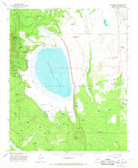
1965 Map of Mormon Lake
USGS Topo · Published 1967About this map
Mormon Lake and its surrounding forest settlements are documented here during a period of active recreational and industrial use within the Coconino National Forest. The landscape is characterized by a high concentration of springs and tanks, such as Spring Beach Spring and La Negrita Tank, supporting local ranching operations like the Flying M Ranch. Evidence of the region's logging and hauling history is visible through the Industrial Long Park Railroad and an Old Railroad Grade winding through Pine Grove Hill.
Find a feature on this map
77 named features on this map. Tap any name to fly to it.
Don’t see what you’re looking for? This feature index may not catch every label — zoom into the map to look around manually.
Map Details
Editions of this 1965 Mormon Lake Map
4 editions found
Other maps of this area

1886 · San Francisco Mtns
USGS Topo · 1:250,000

1887 · Verde
USGS Topo · 1:250,000

1891 · San Francisco Mtns
USGS Topo · 1:250,000

1892 · Verde
USGS Topo · 1:250,000

1894 · San Francisco Mtns
USGS Topo · 1:250,000

1899 · San Francisco Mtns
USGS Topo · 1:250,000

1908 · Flagstaff
USGS Topo · 1:125,000

1912 · Flagstaff
USGS Topo · 1:125,000

1923 · Camp Verde
USGS Topo · 1:125,000

1932 · Camp Verde
USGS Topo · 1:125,000