1965 Map of Mormon Lake
USGS Topo · Published 1976About this map
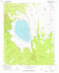
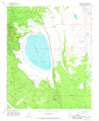
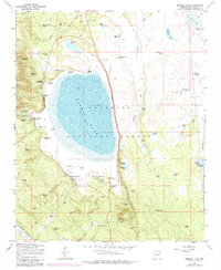
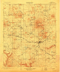
Mormon Lake serves as the central focal point of this Coconino National Forest study, with its elevation recorded at over 7,000 feet in the mid-1960s. The surrounding landscape is characterized by a high concentration of water management features, including Pine Grove No 1 Tank and Section 1 Tank, alongside seasonal watercourses like Walnut Creek. Cultural development is visible in small clusters such as Rockledge and Lakeview, while recreational and organizational sites like the St Joseph Youth Camp, Pilgrim Playground, and Tempe Camp indicate the area's role as a mountain retreat. An Old Railroad Grade and an Industrial Railroad trace the legacy of logging and transport through Fulton Canyon, while the Mormon Lake Lookout Tower and Mormon Ranger Station highlight the active management of these timberlands.
Find a feature on this map
76 named features on this map. Tap any name to fly to it.
Don’t see what you’re looking for? This feature index may not catch every label — zoom into the map to look around manually.
Map Details
Editions of this 1965 Mormon Lake Map
4 editions found

Other maps of this area

1886 · San Francisco Mtns
USGS Topo · 1:250,000

1887 · Verde
USGS Topo · 1:250,000

1891 · San Francisco Mtns
USGS Topo · 1:250,000

1892 · Verde
USGS Topo · 1:250,000

1894 · San Francisco Mtns
USGS Topo · 1:250,000

1899 · San Francisco Mtns
USGS Topo · 1:250,000
1908 · Flagstaff
USGS Topo · 1:125,000
1912 · Flagstaff
USGS Topo · 1:125,000

1923 · Camp Verde
USGS Topo · 1:125,000

1932 · Camp Verde
USGS Topo · 1:125,000