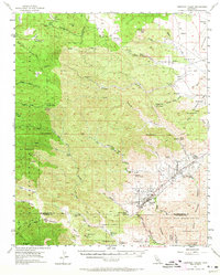
1955 Map of Morongo Valley
USGS Topo · Published 1965About this map
Morongo Valley serves as the central hub of this mid-century survey, situated at the base of the San Bernardino Mountains where the high desert meets the canyon systems. The landscape is defined by its ranching and mining heritage, with several working cattle spreads including The Pipes Ranch, Bain Ranch, and the T Cross K Ranch scattered across the arid terrain. Traces of the region's extraction history are visible near Mineral Mtn at the Rose Mine and Monte Cristo Mine, while the town of Pioneertown stands as a focal point for settlement in the northeast. The presence of the Morongo Indian Reservation and the San Bernardino National Forest illustrates the division of land into federal and tribal management. Significant infrastructure, such as the Colorado River Aqueduct and the Twenty Nine Palms Highway, underscores the area's role as a vital corridor for water and transportation through the California desert.
Find a feature on this map
73 named features on this map. Tap any name to fly to it.
Don’t see what you’re looking for? This feature index may not catch every label — zoom into the map to look around manually.
Map Details
Editions of this 1955 Morongo Valley Map
3 editions found

Other maps of this area

1901 · Southern California Sheet No. 1
USGS Topo · 1:250,000

1901 · San Jacinto
USGS Topo · 1:125,000

1902 · San Gorgonio
USGS Topo · 1:125,000

1904 · Southern California Sheet No. 1
USGS Topo · 1:250,000

1940 · Palm Springs
USGS Topo · 1:62,500

1941 · Edom
USGS Topo · 1:62,500

1942 · Banning
USGS Topo · 1:62,500

1943 · Banning
USGS Topo · 1:62,500

1944 · Palm Springs
USGS Topo · 1:62,500

1944 · Edom
USGS Topo · 1:62,500