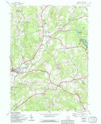
1943 Map of Morris
USGS Topo · Published 1994About this map
Butternut Creek carves a deep valley through the heart of this Otsego County landscape, anchoring a network of small upland settlements during the mid-20th century. The village of Morris serves as a primary hub in the southwest, while scattered hamlets like New Lisbon and West Laurens trace the early road patterns of Pittsfield and Laurens townships. The map is particularly notable for its density of family-named burial grounds, including the Bennett-Weatherly Cem, Chapin Cem, and Lull Cem, which offer significant value for genealogical research. To the east, the recreation-focused lands of Gilbert Lake State Park surround Lake of the Twin Fawns and Gilbert Lake, providing a sharp contrast to the surrounding agricultural and timbered hillsides like Gill Hill. Numerous small gravel and shale pits scattered across the terrain suggest a local economy tied to road maintenance and small-scale resource extraction.
Find a feature on this map
47 named features on this map. Tap any name to fly to it.
Don’t see what you’re looking for? This feature index may not catch every label — zoom into the map to look around manually.
Map Details
Editions of this 1943 Morris Map
3 editions found
Other maps of this area

1910 · Hartwick
USGS Topo · 1:62,500

1910 · New Berlin
USGS Topo · 1:62,500

1912 · New Berlin
USGS Topo · 1:62,500

1912 · Hartwick
USGS Topo · 1:62,500

1915 · Oneonta
USGS Topo · 1:62,500

1915 · Unadilla
USGS Topo · 1:62,500

1918 · Unadilla
USGS Topo · 1:62,500

1918 · Oneonta
USGS Topo · 1:62,500

1943 · Mt Vision
USGS Topo · 1:24,000

1943 · New Berlin North
USGS Topo · 1:24,000