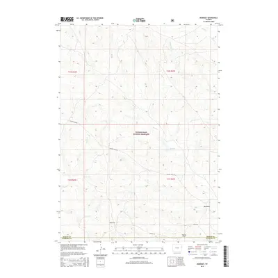
2015 Map of Morrisey
USGS Topo · Published 2015About this map
Thunder Basin National Grassland dominates this high plains landscape on the border of Weston and Niobrara counties. The settlement of Morrisey sits near the southeastern corner, positioned along a drainage system defined by Alkali Cr and Whitney Draw. This 2015 survey illustrates a sparsely populated ranching and grazing environment where water management is central to the land's utility, evidenced by the Sedgwick Reservoir and numerous ephemeral watercourses like Robbers Roost Cr. The road network is limited to primary corridors such as Cheyenne River Rd and Roxson Rd, which traverse the undulating terrain of Bum Draw and Coyote Cr. The map preserves the specific cattle-country topography and section lines of the Wyoming plains, capturing the spatial relationship between isolated settlements and the vast public lands of the national grassland.
Find a feature on this map
16 named features on this map. Tap any name to fly to it.
Don’t see what you’re looking for? This feature index may not catch every label — zoom into the map to look around manually.
Map Details
Editions of this 2015 Morrisey Map
This is the sole edition of this map. No revisions or reprints were ever made.
Other maps of this area

1899 · Newcastle
USGS Topo · 1:125,000

1901 · Newcastle
USGS Topo · 1:125,000

1951 · Morrisey NE
USGS Topo · 1:24,000

1955 · Newcastle
USGS Topo · 1:250,000

1958 · Newcastle
USGS Topo · 1:250,000

1979 · Newcastle
USGS Topo · 1:100,000

1981 · Horseshoe Bend
USGS Topo · 1:24,000

1981 · Threemile Butte
USGS Topo · 1:24,000
1981 · Little Alkali Creek
USGS Topo · 1:24,000

1981 · Lance Creek
USGS Topo · 1:100,000