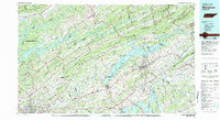
1981 Map of Morristown
USGS Topo · Published 1981About this map
Morristown serves as a central hub in this detailed look at East Tennessee's ridge-and-valley landscape during the early 1980s. The region is defined by the massive reservoirs of Norris Lake, Cherokee Lake, and Douglas Lake, which drastically altered the drainage patterns of the Holston River and Clinch River systems. The map captures a sophisticated network of transportation and industry, featuring the Southern Railway and the Moore-Murrell Airport. Heavy industry is noted at the Young Mine near Jefferson City and the industrial activity around Lowland. Significant conservation and recreation areas are well-established, including the Chuck Swan State Forest and Wildlife Management Area and Big Ridge State Park. Local life is anchored by small communities like Bean Station, Rutledge, and White Pine, with rural landmarks such as Alpha Ch and Lakeview Cem providing important reference points for family historians.
Find a feature on this map
169 named features on this map. Tap any name to fly to it.
Don’t see what you’re looking for? This feature index may not catch every label — zoom into the map to look around manually.
Map Details
Editions of this 1981 Morristown Map
This is the sole edition of this map. No revisions or reprints were ever made.
Other maps of this area

1883 · Morristown
USGS Topo · 1:125,000

1886 · Knoxville
USGS Topo · 1:125,000

1886 · Cumberland Gap
USGS Topo · 1:125,000

1887 · Jonesville
USGS Topo · 1:125,000

1888 · Cumberland Gap
USGS Topo · 1:125,000

1890 · Williamsburg
USGS Topo · 1:125,000

1891 · Cumberland Gap
USGS Topo · 1:125,000

1891 · Jonesville
USGS Topo · 1:125,000

1892 · Greeneville
USGS Topo · 1:125,000

1892 · Knoxville
USGS Topo · 1:125,000