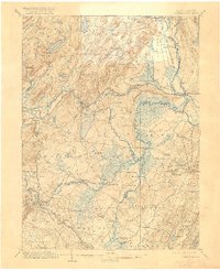
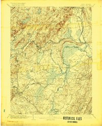
1906 Map of Morristown
USGS Topo · Published 1921About this map
The Passaic River and its complex network of tributaries define this 1906 survey of the northern New Jersey interior. The landscape is characterized by its transitioning water-based economy, where the Morris Canal and its associated feeder navigate the undulating terrain alongside newer rail corridors like the Morristown and Erie RR. Large wetlands, including Great Piece Meadows and Hatfield Swamp, dominate the lowlands, while the industrial and residential growth of settlements such as Boonton and Florham Park is clearly established. Genealogists and local historians can trace the specific placement of early transportation landmarks like Swinefield Bridge and Cooks Bridge. From the northern heights of the Brook Mountains to the eastern slopes of the First Watchung Mountain, the map documents a region of established village centers and vital water resources like the Boonton Reservoir.
Find a feature on this map
110 named features on this map. Tap any name to fly to it.
Don’t see what you’re looking for? This feature index may not catch every label — zoom into the map to look around manually.
Map Details
Editions of this 1906 Morristown Map
6 editions found

Other maps of this area

1888 · Franklin
USGS Topo · 1:62,500

1888 · Plainfield
USGS Topo · 1:62,500

1888 · Morristown
USGS Topo · 1:62,500

1888 · Lake Hopatcong
USGS Topo · 1:62,500

1888 · Paterson
USGS Topo · 1:62,500

1891 · Somerville
USGS Topo · 1:62,500

1891 · Greenwood Lake
USGS Topo · 1:62,500

1891 · Ramapo
USGS Topo · 1:62,500

1892 · Paterson
USGS Topo · 1:62,500

1893 · Plainfield
USGS Topo · 1:62,500