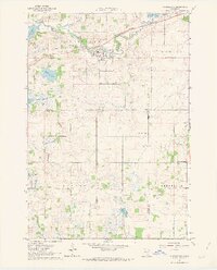
1962 Map of Morristown
USGS Topo · Published 1963About this map
The Cannon River winds through the northern portion of this landscape, connecting the village of Morristown with the sprawling waters of Cannon Lake to the east. This early 1960s survey illustrates a region defined by its complex hydrology and agricultural boundaries, where the Chicago Great Western railroad parallels the river course through Morristown Township. The terrain is punctuated by numerous glacial depressions, forming bodies like Sprague Lake and Hands Marsh, while the southern reaches near Blooming Grove show a transition into more systematically drained territory via Judicial Ditch No 1. Local history is anchored by several rural landmarks, including the Blooming Grove Ch and Corpus Christi Ch, alongside numerous family-oriented resting places such as Emmanuel Cem and Hillside Cem. These features, along with the various Gravel Pits, highlight the local economy's reliance on both the fertile till and the underlying geological deposits.
Find a feature on this map
28 named features on this map. Tap any name to fly to it.
Don’t see what you’re looking for? This feature index may not catch every label — zoom into the map to look around manually.
Map Details
Editions of this 1962 Morristown Map
2 editions found
Other maps of this area

1953 · Saint Paul
USGS Topo · 1:250,000

1959 · Saint Paul
USGS Topo · 1:250,000

1960 · Faribault
USGS Topo · 1:24,000

1960 · Shieldsville
USGS Topo · 1:24,000

1962 · Morristown
USGS Topo · 1:24,000

1962 · Saco
USGS Topo · 1:24,000

1962 · Meriden
USGS Topo · 1:24,000

1962 · Medford West
USGS Topo · 1:24,000

1966 · Waseca
USGS Topo · 1:24,000

1966 · Waterville
USGS Topo · 1:24,000