
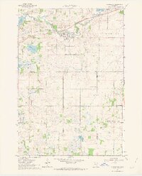
1962 Map of Morristown
USGS Topo · Published 1963About this map
The Cannon River winds through the heart of Rice County, anchoring the settlements of Morristown and Warsaw during the early 1960s. This survey illustrates a landscape defined by its glacial hydrology, where Lower Sakatah Lake and Cannon Lake are connected by the river's path, and the Chicago Great Western railroad tracks parallel the water through the northern townships. The southern portion of the map transitions into the agricultural reaches of Blooming Grove and Deerfield, revealing a rural network of country churches and community focal points.
Find a feature on this map
28 named features on this map. Tap any name to fly to it.
Don’t see what you’re looking for? This feature index may not catch every label — zoom into the map to look around manually.
Map Details
Editions of this 1962 Morristown Map
2 editions found
Other maps of this area

1953 · Saint Paul
USGS Topo · 1:250,000

1959 · Saint Paul
USGS Topo · 1:250,000

1960 · Faribault
USGS Topo · 1:24,000

1960 · Shieldsville
USGS Topo · 1:24,000

1962 · Saco
USGS Topo · 1:24,000

1962 · Meriden
USGS Topo · 1:24,000

1962 · Medford West
USGS Topo · 1:24,000

1966 · Waseca
USGS Topo · 1:24,000

1966 · Waterville
USGS Topo · 1:24,000
1966 · Kilkenny
USGS Topo · 1:24,000